


Luray Front Royal Strasburg Virginia Historical Rare Antique Original USGS discount Topo Map 1905 30-minute Topographic
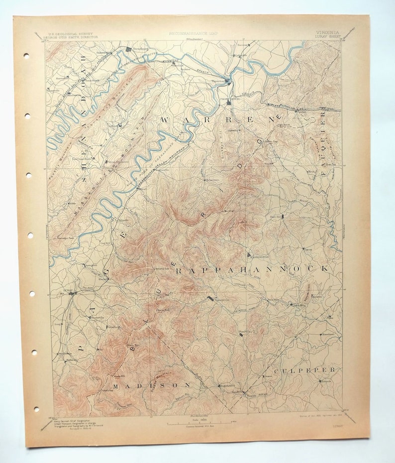
This antique sheet is a 1905 edition of the Luray Virginia USGS topographic map. It is an authentic 111-year-old 1910 United States Geological Survey print in excellent condition.
SHEET NOTES
Fascinating historical snapshot, surveyed before the existence of the modern road/highway system, shows historic travel routes, rail lines, river crossings, and placenames, uncommonly well-preserved sheet.
HOW THIS MAP CAN BE USED
In addition to making a fascinating conversation piece, this sheet would look great in a frame or on display, make a unique and prized gift for anyone interested in this area, be perfect as a reference for genealogy studies or general historical research, or fill that missing piece in your collection.
* Title-> Luray
* State-> Virginia
* Edition-> 1905
* Printed-> 1910, thick paper stock
FEATURES SHOWN ON THE discount MAP
The Luray 30-minute map shows cities and towns, roads, railroads, rivers, creeks, elevation contour lines, public land survey lines, county, state, and other administrative boundaries as they existed at the time of the survey in 1884 and 1886.
* Series-> 30-minute
* Scale-> 1:125000
* Contour Interval-> 100 Foot
SURVEYING AND CARTOGRAPHY
The Luray map was field surveyed before aerial photography methods were widely used in map data gathering. It was drawn by skilled cartographers at the United States Geological Survey based on plane table field survey information as well as information gathered from local residents in the area. This piece displays the remarkable abilities of early government map makers, who placed a strong emphasis on creating complete, accurate, and cartographically appealing maps.
* Surveyed-> 1884 and 1886 Field Survey
* Geographer-> Henry Gannett
A VALUABLE HISTORICAL RECORD
Maps from the USGS 30-minute series have been out of print for many years. They have never been common and original prints are increasingly difficult to find. For areas where the 30-minute map was produced, it is usually the first large-scale survey done by the USGS for that area. These are a valuable historical record, as they contain many placenames and features that have been dropped from more recent series' and editions.
* Sheet Dimensions-> 16 1/2 x 20 inches
* Map Dimensions-> 13 5/8 x 17 1/2 inches
* Map Coverage-> 27 x 35 miles
SHEET CONDITION: Excellent
* Sheet Notes-> very lightly handled, never folded, smooth and flat, lightly age-toned paper
* Map Area-> flawless map area
* Collar Area-> no wear, no markings, hole punches along left collar
PLACENAMES
The following places are found within the boundary of this quadrangle. They may or may not be shown or labeled, depending on the map series and vintage.
* Cities and Towns-> Front Royal, Strasburg, Luray, Woodstock, Stanley, Toms Brook, Washington, Sperryville, Riverton, Rileyville, and others
* Counties Covered-> Clarke, Culpeper, Fauquier, Madison, Page, Rappahannock, Shenandoah, and Warren
* Federal Land Units-> Shenandoah National Park, George Washington National Forest, and Shenandoah Wilderness
* Rivers and Streams-> North Fork Shenandoah River, South Fork Shenandoah River, Rappahannock River, Shenandoah River, Goose Creek, Hazel River, Cedar Creek, Passage Creek, Robinson River, Thornton River, and others
* Water Bodies-> Lake Arrowhead, Caynor Lake, Barr Pond, Lake John, Sawyer Pond, Digulin Pond, Liverman Pond, Lake Front Royal, Lake Mosby, Sweeney Lake, and others